Itineraries

Between the Via Francigena and the Sea: 4 Trekking Routes in Tuscany

Tuscany is one of Italy’s most beloved regions for hikers, and its most famous itineraries – the Tuscan stages of the Via Francigena, the Chianti loops, the ridges of Monte Amiata – are now visited in every season by experts and novices alike. But there are still lesser-known trekking routes in Tuscany: little-trodden trails that, precisely for this reason, retain their charm intact and surprise with the variety of environments they cross – dense woods and open pastures, streams to ford and vineyards, ruins, historic buildings, and scenic viewpoints over the sea.

The Val di Cecina is a case in point, as an “in-between” territory: to the east, the route of the Via Francigena with its slow flow of walkers; to the west, the Tyrrhenian Sea with the beaches of the Etruscan Coast. This is where the Via Francigena Mare runs, the path connecting the Francigena to the coast along ancient salt routes, which in its wildest stretch crosses the Monterufoli-Caselli Nature Natural Park.


This is exactly where the four Tuscany trekking routes described in this guide begin: marked trails tracked with maps on Wikiloc, suitable for different levels, from beginner-friendly hikes to a long loop for those who want to dedicate a whole day to the walk.

Via Francigena Mare: the path linking the Via Francigena to the Etruscan Coast

The Via Francigena Mare – the name under which the regional interest route “Dalla Via Francigena alla Costa degli Etruschi” is promoted – is an itinerary of about 170 kilometers and 7 stages connecting the Val d’Elsa to the Tyrrhenian Sea. It can be walked in both directions, starting from the Certaldo railway station or the Cecina one: on one side, the iconic Francigena landmarks such as San Gimignano and Gambassi Terme; on the other, Bolgheri, Bibbona, and the sea, passing through Volterra and the Alta Val di Cecina.

The route revives the network of the ancient Vie Salaiole, the trade roads along which, for centuries, salt from the Volterra salt pans traveled by mule train toward Florence and Siena until meeting the Via Francigena. It’s the variant that leaves the route most frequented by pilgrims to immerse itself in the woods, ending at the sea.

One of the stages of the path starts right from Villetta di Monterufoli, in the heart of the reserve, and descends toward Bolgheri and its cypress-lined avenue. The Tenuta di Monterufoli is included on the route as a stopover and overnight point: the four trails we’ll look at connect directly to the Via Francigena Mare, as loop variants and branches for those who want to explore the reserve before setting off again.

The territory is ideal for those seeking scenic treks near the sea, but also for those who want to plan a holiday alternating relaxing days on the coast – in Cecina, Bibbona, Castagneto Carducci, San Vincenzo – with hikes in the woods and local wine tastings, staying overnight at a farmhouse. In this surprising territory, in fact, within just a few kilometers you pass from the beaches of the Tyrrhenian coast to the woods of the Colline Metallifere, from white gravel roads to the vineyards of the Val di Cornia.

Hikes in Tuscany's Wildest Nature from the Monterufoli-Caselli Natural Park
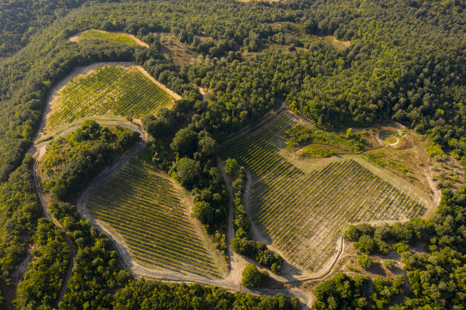
The Monterufoli-Caselli Nature Reserve covers almost 5,000 hectares across the municipalities of Pomarance, Monteverdi Marittimo, and Montecatini Val di Cecina. It’s one of the largest and wildest areas in the region: woods of Turkey oak and cork oak, Mediterranean scrub, streams, fords, and old mining roads make up a landscape very different from the softer, more familiar image of the Tuscan countryside.

It’s also an interesting area from a geological and mining point of view. Between the 19th and 20th centuries, lignite and magnesite were mined here, transported by a mining railway active until 1929; much earlier, in the 16th century, the Medici had chalcedony quarried in these hills, a semi-translucent quartz used in Florentine workshops for mosaics and hardstone inlay work. This is why hikes in the reserve are not simple walks through greenery: along the way, you continually come across traces of Tuscan history left imprinted on the landscape.

The starting point of the four itineraries is the Tenuta di Monterufoli, a property of the Tenute del Cerro group, which spans over a thousand hectares within the reserve. A farmhouse with a pool and restaurant housed in the buildings of the old mining station: the trails start and end right here, which makes organizing the day simple even for those unfamiliar with the area.


1. Sentiero delle Sughere: Trekking Through Pastures, Vineyards, and Cork Oak Woods

Distance, elevation gain, and type: 5.33 km • one way • medium difficulty • elevation gain 110 m uphill / 131 m downhill • on foot, by bike, by mountain bike, or on horseback

The Sentiero delle Sughere is the shortest of the four suggested trails, but also one of the most varied. The first stretch crosses fields, pastures, and olive groves, with the Torre del Pozzo of the lignite mine along the way: a shaft that reached over 190 meters in depth. Upon reaching the ruins of the Villetta di Monterufoli and the Chiesetta del Sacro Cuore, the view opens up over the Conca di Villetta, the Tenuta’s inner valley. It’s right from the Villetta di Monterufoli that the stage of the Via Francigena Mare descending toward Bolgheri begins, so for a stretch you walk along the start of the larger itinerary.

Past the little church, you enter the holm oak and downy oak scrubland, skirt the Terra Rossa vineyard, and after about a kilometer through the Sughere woods, reach the cork oak grove: it’s worth stopping to admire the monumental cork oak specimens. The return leg can become the most beautiful part of the experience: you descend along the Ritasso stream and walk along the riverbed, before climbing back up onto the flat trail that leads back to the Tenuta. With children and teenagers used to walking, it’s also one of the most accessible routes for family trekking in Tuscany, provided you avoid the hottest hours of the day.

2. Sentiero Poggio Mattonelle: a hike with panoramic views over the Val di Sterza

Distance, elevation gain, and type: 9.95 km • loop • medium difficulty • elevation gain 303 m • maximum altitude 512 m • on foot, by bike, by mountain bike, or on horseback

The Sentiero Poggio Mattonelle shares the first 1.5 km with the Sentiero delle Sughere, then begins to climb: it passes by the Podernovo Vermentino vineyard, then, along an increasingly winding road, regular stones resembling small tiles start to appear, giving the hill its name.

After about 500 meters, a detour leads to the panoramic viewpoint from which the view opens up from Monte di Canneto across the entire Val di Sterza: dense woods, hills, and nature with a primordial feel. It’s one of the best spots to stop at sunset, and in spring, various species of wild orchids bloom in the clearings of the woods. The trail reaches the top of the hill – the 512 meters of maximum altitude among the four itineraries – and descends again to close the loop. Perfect for those seeking hikes with panoramic views in Tuscany, and it’s an excellent higher-altitude variant for those walking the Via Francigena Mare: just half a day’s detour before resuming the path toward the coast.


3. Sentiero dei Ponti Fantasma: An Easy Trek Along the Old Mining Railway


Distance, elevation gain, and type: 9.01 km • loop • easy difficulty • elevation gain 158 m • on foot only

The Sentiero dei Ponti Fantasma e Poggio Miniera – also known as the “Trekking dei Ponti” – is probably the most scenic of the four recommended routes at Monterufoli: it follows the route of the old mining railway that, between 1872 and 1928, transported lignite to the Cecina-Volterra line. It’s the ideal itinerary for beginner-level hikes on the Tyrrhenian coast, and for those arriving along the Via Francigena Mare, it’s the perfect loop to fit into a rest day at the Tenuta.

From the farmhouse’s entrance road, a short detour leads to the remains of the first railway bridge over the Rivivo stream; you continue along the old track, passing the steccaia weir that once powered a mill. Then, one after another, the “ghost bridges” appear: four imposing stone arches spanning the Ritasso stream, abandoned for nearly a century in a landscape that has returned to the wild. After the fourth bridge, you reach the trench cut into the rock for the train’s passage; the return leg climbs back up along the Malentrata stream to the Sangiovese vineyards, with one last surprise 700 meters from the finish: a small waterfall on the Rivivo.


4. Sentiero delle Stallacce e Malentrata: A Loop Itinerary Through the Reserve


Distance, elevation gain, and type: 17.83 km • loop • medium difficulty • elevation gain 518 m • maximum altitude 495 m • on foot, by bike, by mountain bike, or on horseback

The Sentiero delle Stallacce e Malentrata – the “Mine-Stallacce-Malentrata” loop – is the longest route: almost 18 kilometers, over 500 meters of elevation gain, a full day of hiking. It’s the most complete itinerary for those seeking a true hiking loop in the hinterland of the Tuscan sea, and it matches the length of a stage of the Via Francigena Mare: for those trained to the walking pace, it’s the best way to get to know the reserve in depth without moving base.

The first stretch alternates between streams, woods, fields, and pastures, with a small waterfall and the remains of an old mill at the Mulino del Rivivo site. You continue toward the ruins of Gabbra, skirt the vineyards, and climb up to the Pian di Seta hill – the same one that gives its name to the Tenuta di Monterufoli’s Vermentino. Along the Malentrata stream, the tunnels of an old magnesite mine open up; at the Stallacce junction, the panoramic viewpoint next to the ruin, at about 340 meters of altitude, is worth a stop. The final climb leads to Malentrata, the highest point of the loop at 495 meters, from which you walk along the ridge before descending back toward the farmhouse.

Practical tips for organizing a trek on the Via Francigena Mare

The best periods for hiking in this area are spring and autumn. From March to June, the woods of the Monterufoli-Caselli Nature Reserve are at their liveliest and wild orchids bloom along the Poggio Mattonelle: a good choice for spring treks in Tuscany on lesser-known trails. From September to November, woods, vineyards, and gravel roads take on warmer tones: it’s the right season for autumn treks in Tuscany, even on the longer loops.

Even in summer, the woods stay cooler than the coast, especially along the streams. It’s best to set off early and choose the shorter or more shaded trails. For those who love admiring the view at sunset, Poggio Mattonelle is the right route at that time of day; for a dawn trek, it’s better to opt for a short itinerary within the reserve, so you can then reach the coast for the rest of the day.


Online Maps and Suggested Routes for Family Hikes


All four trails can be viewed on the Tenuta’s Wikiloc profile: downloading the track onto a hiking app is the wisest choice, so you always have an offline map available. And to explore other areas of the region, here you’ll find our recommendations on the most beautiful walking routes in Tuscany.

For beginner hikes, the best choice is the Sentiero dei Ponti Fantasma, classified as easy with limited elevation gain. For trekking with children, the shorter routes are best, avoiding the hottest hours and the days following heavy rain, when the stretches near the streams become slippery. On the other hand, being able to cross bridges, pass ruins and streams, and see grazing animals makes the experience interesting for younger children too, if accompanied with care.

Three out of four trails are also suitable for bikes, mountain bikes, e-bikes, and horseback riding. They also lend themselves well to trail running, thanks to moderate elevation changes, compact terrain, and almost no traffic. The tenuta’s gravel roads are ideal for cycle tourism, with the option of e-bike rental directly at the Tenuta: it’s no coincidence that the Tuscany Trail, one of Europe’s best-known bikepacking races, also passes through here.


What to pack and how to dress


What should you pack for a day of trekking in Tuscany? Water, a snack, the GPS track downloaded onto your smartphone, a power bank, a hat in the warmer months, and a light jacket in the shoulder seasons. Recommended clothing for hikes near the sea should account for the alternation between exposed areas and shaded stretches: you’ll need trekking shoes with good grip, lightweight breathable layered clothing, and sun protection. After rain, stretches along streams and riverbeds can be muddy: it’s best to avoid smooth soles.


Where to stay and eat: farmhouse and La Miniera Restaurant at Monterufoli


All four trails start from the Tenuta di Monterufoli: this makes it easy to plan a weekend stay here, with a short route on arrival day and a longer loop the next. The same goes for those already on the trail: the Tenuta is an official stopover and overnight point on the Via Francigena Mare, and the stage toward Bolgheri starts right from here.
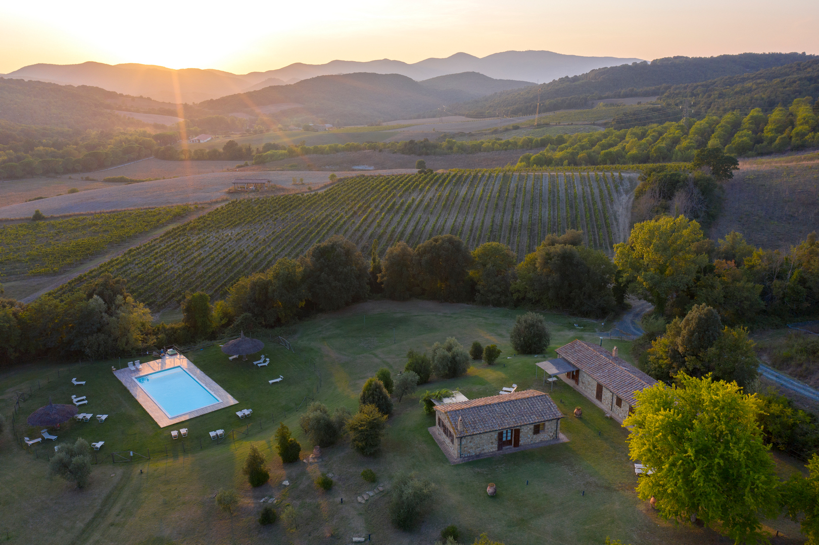
The agriturismo of the Tenuta occupies the restored buildings of the old mining station: the main house, called La Miniera, with rooms, a suite and an independent apartment; the Scuderie and the Casa delle Guardie with self-contained apartments overlooking the valley. The property is completed by a pool, wine shop and tasting room.

At the end of the walk, you can treat yourself to dinner at ristorante La Miniera to close out the day with seasonal Tuscan dishes, local products, and a mix of land-based and a few fresh seafood offerings. Paired with them, the wines produced on the Tenuta: the Vermentino Pian di Seta and the Poggio Miniera Val di Cornia Rosso DOCG, whose name carries the mining history of Monterufoli. For those who want to experience the trails through a wine-focused lens, the estate also offers short treks among the vineyards and off-road tours with tasting.

Between the Via Francigena and the Sea: 4 Trekking Routes in Tuscany

{title}

{description}

All the news

About the estate

What to do in Montepulciano in summer: events, tastings, and vineyard experiences
Learn more
The Etruscan Coast beyond the sea: At Monterufoli, among hiking trails, relaxation and wine
Learn more
Cellars Open to the Future: How the Winery Visit Is Changing Through Design, AI, and Sustainability
Learn more
Complete guide to the “Pievi” and the zoning of Vino Nobile di Montepulciano
Learn more
Why choose a wine resort in Tuscany for team building?
Learn more
Tenute del Cerro’s Wine Club: how it works, what it includes, and the benefits for members
Learn more